This blog covers my Smoky Mountain hikes; it also includes a link to pictures from one of my cross country ski ventures.

Wednesday, November 29, 2006

Noland Divide 3.7pd, Noland Creek 5.1n, & return to start 8.8pd (17.6 mi. total)


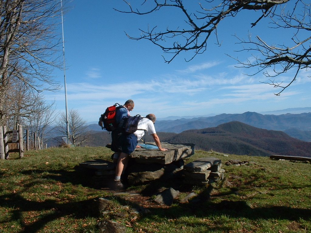
Picked up Dennis McAdams at SVC at 7:00. We started on the 3.7 mi. Noland Divide section at 7:45 and finished it at 9:05; this is a trail that we both had previously done. We then began on Noland Creek trail; we both needed this middle section which is 5.1 miles. (The picture is of Dennis with Noland Creek in the background. When we came to our 1st water crossing we changed to our water shoes; I left mine on for the 2nd which was only ~50 yards from the 1st. The 3rd and last water crossing was ~0.75 miles later. On the calves the water was quite cold; the remaining water crossings on this trail had log bridges. We reached Campsite 64 at 11:30; we ate a leisurely lunch at this point (junction of several trails); there were ~6 picnic tables in this area which is most unique for a campsite.

At about noon we began to retrace our steps on the two trails just completed. When we reached the first non-bridge water crossing, we both put on our water shoes and kept them on for the remaining two. Although my feet took the water well relative to temperature, I could really feel it on my calves. I had taken off my knee brace; however, water seldom went above my knees. I had carried a second pair of socks to wear in my water shoes; this made them more comfortable. It took us 2 hr. 15 min. to complete this 5.1 mile section.

We immediately began the final leg of our hike on the 3.7 mi. section of Noland Divide back to by vehicle. Shortly after we started I decided to go a little faster so I could ice my knee; I also wanted to get an aerobic workout. I completed this section in 1 hr 23 mn; that was 3 mn slower than going down the same trail. Although I would have liked to beaten my going down time, I guess I should be satisfied for at that point I had hiked 14.5 miles.

.

Tuesday, November 28, 2006

Fork Ridge Trail 5.1n & 5.1pd (10.2 mi. total)

Because the road to Clingmans Dome from Newfound Gap closes December 1, I have endeavored to complete all trails emanating from this road. Today my goal was to complete Fork Ridge; its trailhead is 2.5 mi. up Clingmans Dome Road. Because another hiker and I planned to do another trail from this road on Wed., my original plan was to do Fork Ridge on November 30; however, a forecast of rain for Thursday made me up this hike to Tuesday even though the short notice was apt to preclude getting anyone to go with me. However, Ellie Doughty came to the rescue. I have spoken before of Ellie (one who has completed all of the trails) doing the arduous Goldmine Loop so she could help another hiker; today she helped me.

I picked up Ellie at Food Lion at 8:00 and we proceeded to Newfound Gap; as we approached the Gap it started getting foggy. We proceeded past it until we reached the Forge Creek trailhead; there it was extremely foggy and the trailhead appeared to be blocked. We proceeded to Clingmans Dome where telephone contact could be made with the Park Service; we learned that all trails were open so we proceeded back to the Forge Creek Trailhead. When we got there the fog had dissipated to the extent that the trailhead was visible and what we thought was a blocked trailhead was just a precaution to keep hikers from stepping off the parking area into a sunken area adjacent to the trailhead.

Because it was quite foggy, I decided to leave my camera in the car. We got started ~10:00. Because of the weather, a relatively nice trail was not that scenic. The trail dropped ~3000 feet in its 5.1 miles; obviously we would have that amount of climb on our return to my vehicle. We ate lunch at the trail’s terminus by Deep Creek; across the stream we could see the Deep Creek Trail which emanates from the Newfound Gap Road and terminates ~15 miles South at the Deep Creek Campground. (That is on my list of future hikes.)

On our way back we met another couple; hopefully they made it out before the weather got a little worse. We had a very slight rain on our return trip and reached my car ~3:00. Ellie drove so that I could ice my knee. Much to our surprise ~5 miles prior to Sugarlands Visitor Center the sky cleared the weather matched the forecast. That is an example of why one often has difficulty predicting the weather in the mountains.

Monday, November 20, 2006

Middle Prong--4.1pd, Greenbrier Ridge--4.2n, AT Derrick Knob to Buckeye Gap--2.4n, Miry Ridge--2.5n, 2.5pd, Jakes Creek--2.9pd (18.6 mi. total)


Had planned to do Noland Divide and first section of Noland Creek in & out; however, those I queried at Judy’s 900 Mile dinner last evening discouraged me from doing this (i.e., very tough bugger at this time of year). I called my hiking partner Dennis and he already had the above hike in mind because closure of the Clingmans Dome Road precluded following our original plan.

Met Dennis at Elkmont at 7:00 a.m.; we left his car there and proceeded in mine to Tremont to begin our hike. Greenbrier Ridge had a bit of “up” and there was up to one inch of snow on the trail; however, we were very warm and had to shed some apparel. We did have one stream crossing that we had overlooked. Even if we had had our water shoes we may have not used them; I was wearing my old boot with a tear in the Goretex that the stream managed to find. We met our first two backpackers coming down; they were bundled up but were not using sticks (hence limited circulation to hands and arms).

Our short section of the AT had unique snow formations on the trees; that is Dennis in the picture. We finished the AT section and had lunch; it was in the low 20’s by then so I added a shirt and Dennis added a light jacket. Our fingers got a little cold.

Miry Ridge was a fairly easy trail; on it and Jakes Creek trail we met an additional 12 backpackers.

We arrived at Dennis’s car ~3:35; we really legged the last section for Dennis had an appointment in Morristown. He hustled me back to my vehicle in Tremont and then I made a leisurely trip back home.

Friday, November 10, 2006

Catlooche Divide (1.8n), Hemphill Bald (5.5n), 7.3pd, road 1.5 & 1.5 (17.6 mi.)


The Twentymile hike that I had planned for 11/8 had to be cancelled because of high stream levels on Wolf Ridge and Twentymile Loop trails. I rescheduled it for 11/10 and planned to join our Wed. group and hike Maddron Bald; however, in the rain I was the only one at the meet-up at Food Lion for the latter hike. Thursday evening Dennis McAdams, after checking with the Back Country office at SVC, called to advise me that the water levels in the Twentymile area were still too high. We decided to do two trails in the Catalooche area.

I picked up Jim Harb at 6:30; we met Dennis at 7:30 in the Shoneys’ parking lot at the junction of US 321 and I 40. We proceeded in Dennis’s car and left it at the gate to the Appalachian Highlands Science Learning Center at Purchase Gap; we then proceeded on foot to the junction of McKee Branch Tr and Cataloochee Divide Tr. (a distance of 1.5 miles).

Our trails today are on the NE-edge of the GSMNP and often next to a fence that separates the GSMNP from private property. When we came to the Swagg Resort, we stopped at their "viewing" area ~0.25 mi. from their buildings (1st pic).

The next pictures were taken at Hemphill Bald; the Bald is adjacent to the GSMNP and these pictures were taken after we went through the gate into the private property. The first pic shows snow at a ski resort in the Catalooche valley; at this time of year they had snow only on the lower part of their run where it was protected from the sun. We could see a few skiers and/or snow boarders plus the moving chair lifts. The next pic shows Jim and Dennis looking at a display of the panoramic view of the area fixed to a "rock table". The view here includes Mt. Mitchell and is perhaps the most tremendous that I have ever seen in my covering more than 700 miles of trails in the GSMNP.

In slightly less than three hours we had covered 7.3 miles to Polls Gap; we ate lunch at this point and I nursed my Achilles tendon blister that was apparently caused by my new boots (I should have attended to it when the first symptoms were realized). We then turned around and retraced our steps. On our return from a distance we saw a heard of deer (at least 7); some were jumping the fence from private land back into the GSMNP and then we noted right adjacent to us in the park were a couple that preceded the rest. Shortly we came closer to two deer on a bald; although they can be seen in this pic, the background view is more striking.

After we passed The Swagg again there were some horseback riders who had tied up next to our trail which was adjacent to The Swagg's fence. One said that staying there cost ~$700/night; that seems a little high. We arrived at our trail starting point in 3 hours (a few minutes slower than our trip in). We then had the 1.5 mile walk back to Dennis's car.

Wednesday, November 01, 2006

Gregory Ridge (5.0 pd) & Gregory Bald (2.0 to AT n) in & out (14 mi.)


Picked up Jim Harb at his home at 7:15; at the Townsend Y we met Dennis McAdams, Janetta Baker, and Bob Bolinger at ~8:00. We took two cars via the Cades Cove Loop and Forge Creek Rd to get to the Gregory Ridge Trail head. Bob and Janetta planned to hike Gregory Ridge (5 mi.) and then Gregory Bald (2 mi.) to Doe Knob in and out. Although I had completed Gregory Bald, I had committed to return via it with Jim and/or Dennis (5.3 mi.) to Parson Branch Rd., and then walk ~4 mi back to my vehicle at the end of Forge Creek Rd.

The Cades Cove traffic slowed us down considerably on our way to Forge Creek Rd.; tourists were stopping for every deer they saw. Thus we did not get started on Gregory Ridge trailhead until ~9:30. It took ~3 hours to comple it and the 2 mile section to the AT (i.e., Doe Knob--these 2 miles were my only new ones on this hike). After we had retraced our steps back to the Gregory Ridge trailhead, Dennis and Jim decided to forego Gregory Bald trail and return via the way we came on Gregory Ridge. They then went on and I waited to advise Bob and Janetta that all 5 of us were doing the same thing; I then attacked the trail for I typically endeavor to get back to our cars so that I can ice my knee and not keep the others waiting. When everyone was back, I shot the picture of my fellow hikers under Bob’s tailgate.

On the trip back we encountered a coyote on Forge Creek Rd (see pic) and a number of turkey blocking the road. In addition to many tourists on the Cades Cove Loop, from my driver’s seat I was able to take the picture of a buck. By the time we dropped Dennis off at the Townsend Y it started to rain and it rained on Jim's and my trip back to Louisville.