This blog covers my Smoky Mountain hikes; it also includes a link to pictures from one of my cross country ski ventures.

Wednesday, March 31, 2010

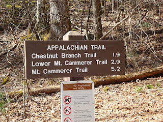
Post 900 Hike #102: Chestnut Branch--2.1, AT--1.0 & 2.3 (to Mt Cammerer Trail), AT 2.3, 1.0, 1.9 (to Davenport Gap)

I organized this hike to fulfill some of the 900-mile trail needs of Theresa Yu; although I had also hoped that some of Doug Jerger's and John Hutsenpiler's needs would be met by this hike, of the latter two only John was able to go. Bob Bolinger and BZ Lane also joined us on this hike.

I picked John at Lakeside Market at 07:10, Theresa at Krogers at 07:25, Bob at McDonalds in Sevierville at 08:20, and BZ near US 321 junction with I-40 at ~09:00. We then proceeded on U.S. 40 until its last exit (i.e., due to its closure because of rock slide, Exit 451). We arrived at Deep Creek Ranger Station ~09:20.

We proceeded up Chestnut Branch and arrived at its junction with the AT at 09:25. Then it was on to two legs of the AT; all trails from the start were basically up. We met several groups of backpackers plus a few others; one group was from Kansas City and I believe were doing all of the AT within the GSMNP (i.e., 76 mi.). BZ and I led and kept a relatively good pace.

The first picture, hopefully if enlarged, will enable one to see the A/C control tower and the bald in the background (Max Patch); both are on the AT outside of the GSMNP.


Although it was my original plan to retrace our steps to my SUV, and then BZ and I would pick up the others at Davenport Gap, I realized that if I did the 1.9 mi. (last section) of the AT, I could could count it towards completion of my Geezer map (i.e., complition of the 900 mile requirements after age 75). Bob most willingly took my place to go with BZ to retrieve my SUV.

The next picture is of those who accompanied me on this hike; from left to right are John, BZ, Teresa, and Bob.


I took this picture just a few feet prior to reaching Davenport Gap; except for Chestnut Branch, it covers the guts of our hike.


I was cleaning my boots at Davenport Gap when Theresa and John arrived; about 15 min. later BZ and Bob arrived in my SUV. We then proceeded on our long return trip home, dropping off my passengers in reverse order. After stopping for a take-out supper at Buddy's Barbecue, I arrived home ~18::15. The hike was only 10.8 mi. but the drive was 149.5 mi.; nevertheless, although this was not the most efficient use of time and resources, it enabled Theresa and John to complete 7.3 mi. of their quest to complete requirements for membership in The 900 Miler Association. It also enabled me to comolete the same number of miles in my quest to complete the 900 miles after reaching age 75.

Wednesday, March 17, 2010

Post 900 Hike #101: AT (1.7, 1.0, 1.7) Charlie's Bunion & return

I picked up Theresa Yu at Krogers and we proceeded to The GSMNP; at SVC we were joined by BZ Lane, Bob Bolinger, and Cecil Rowe. We proceeded to Newfound Gap in BZ's Jeep Wagon; from there we set out on a NE direction on the AT. As we reached a greater elevation, our temperature centered around 31.7 F. A little prior to Icewater Springs shelter, Bob donned his his new snowshoes; I'll comment more on this later.

The first picture is of the Icewater Springs shelter on the AT. (We ended up returning there for lunch, since much of this area's AT is on a windy ridge, and our sojourn to Charlies Bunion was similarly devoid of windless respites.)


Charlies Bunion provides magnificent views; Cecil is pointing out some to Theresa. The next picture is one that Bob took; from left to right it is BZ, me, and Theresa on top of "the bunion"(a big rock). (As you have probably noted in my prior blogs in which Bob has contributed a picture, the quality of his photos is truly phemomenal.


This short segment of the trail off the AT to Charlies Bunion is daunting as you approach the Bunion; all of us, however, wore crampons throughout the hike. Because I was taking many pictures, I was the last one to leave. With the slope dropping precipitously to my right (BZ had said that if you fell to the downside of the trail, one would not stop until s/he traversed ~1,500'), I found that by inverting my left foot with forcible steps I was quite comfortable.

The next picture is of Theresa going up a rise after descending from Charlies Bunion; you'll note that she is quite inboard on the trail, and when this picture was taken, was not using her hiking poles (I guess that I should reprimend her for this, for I am such a firm believer in the utility and use of them.)


In the last picture presented I wanted to get a picture of Bob on his new snowshoes prior to his taking them off at lunch. Although his snowshoes would be very useful on deep snow trails, after the trail has been tramped down and sort of a trench has been created, their utility is diminished.


After lunch we met several contingents of hikers; they included backbackers headed for Maine, college students from Mississippi who could not have been worse prepared for their plan to go to Charlies Bunion, a slightly better prepared couple, a really prepared couple, and as we approached Newfound Gap many tourists who were just endeavoring to walk a few yards on the trail. I had gone ahead of our group of five (when I am in the picture-taking mode I'm usually last) in order to take a picture of my cohorts as they descended to Newfound Gap; the mass of humanity precluded doing so.

When we were back in BZ's SUV, at my request he drove a couple of hundred yards on US 441 in order that I could determine the feasiblity of going skiing (Bob would bring his snowshoes) on the road to Clingmans Dome Thursday or Friday. However, as sort of anticipated the road (closed to vehicular traffic until April 1st but open to others) is now closed to everyone for at least a couple of months (stimulus dollars at work).

On the way down from Newfound Gap on U.S. 441, much to our surprise one vehicle had gone off the road on a cruveless section and we were held up for a few minutes. Later on after Theresa, Cecil and I were in my SUV on the West side of Sevierville on U.S. 411, we were held up again for what appeared to be quite a severe accident. Somewhat to our surprise we subsequently met emergency vehicles (probably from Seymore).

Several of us had been endeavoring to finish off our winter hiking season with unique, beautiful, and sometimes challenging hikes. We truly have had a lot of winners this year! Assuming that I present at Wilderness Wildlife Week again in Pigeon Forge next January on X-C skiing and hiking on snow and ice, I'll have a raft of new pictures.

Wednesday, March 10, 2010

Post 900 Hike #100: Alum Cave to LeConte & Return

This is a snow hike that Bob Bolinger, BZ Lane, and I have been trying to schedule for two weeks; we were finally able to do it. It is the same hike that Bob and I did on 12/30/09; we did it then in order that I would have some good ice pictures to show at my presentation at WWW in Pigeon Forge on 1/11/10. On that hike we encountered more ice on trail than we had ever experienced; however, today we expected that much of the ice would be covered by snow; it was and much was melting for the temperature was at least in the high 40's at lower elevations.

Cecil Rowe and Charlie Woodward joined us; Cecil and I left his house ~0715. About one hour later we arrived at Sugarlands Visitor Center--BZ was waiting and Bob and Charlie arrived momentarily. Not sure what time we arrived at Alum Cave Parking Lot for we made one sojourn first; we all put on our ice crampons before hitting the trail.

BZ and I went ahead; at ~2.2 mi. we were just walking in front of Alum Cave Bluff when some big ice "particles" fell from the cave's lip in front of us. These were big hunks; if one of them were to hit either of us on the head, it would probably have been our last hike. We hustled to the shelter of the cave to wait to warn our three cohorts when they arrived; while we were waiting no other ice hunks fell and I took this picture.


If one closely examines the next picture one will see a little nitch in the mountain against the sky (~45% of the way across from L to R). This picture is meaningful to me because (1) it puts our hike in perspective--our terminus was ~0.5 mi. beyond this point and (2) on 12/30/09 Bob coaxed me into walking back to him around a corner of a precipice past this point (that picture is now my desktop on my 3-computers).


Believe BZ and I arrived at LeConte Lodge ~1230. We ate our lunch on the porch of a cabin; as you'll note on the picture of the lodge, its porch was too laden with snow to sit on it. The elevation at the junction of Alum Cave trail with Rainbow Falls trail is ~6,300 ft.; at this point I assume it's at least a tad higher. (Ironically, Bob and I ate our lunch on the same cabin porch on 12/30/09).


After we had finished our lunch we wanted to move because we were getting cold and we also thought that we had better check on our 3-cohorts. Just as we were about to leave they showed up. However, because we wanted to get our blood moving again, BZ and I started our downward trip. The last picture presented shows BZ in somewhat of a foggy haze just a few hundred yards from the lodge and cabins on the level section of Alum Cave Trail.


The return trip was somewhat uneventful, although neither of us likes to go downhill on snow and ice. As previously stated, much of the ice that Bob and I saw on 12/30/09 was covered with snow, for we have had a lot of snow in the GSMNP this winter (see entries for prior 2010 hikes/X-C ski entries). For example, although Alum Cave offers a cable to grasp in some its sections, at times the cable was either at the level of our boots (because of deep ice and snow) or reachable only if we had arms 2-5 times as long as ours. It has been a very unique winter in the GSMNP.

Labels: