This blog covers my Smoky Mountain hikes; it also includes a link to pictures from one of my cross country ski ventures.

Wednesday, April 28, 2010

Post 900 Hike #104: Grapeyard Ridge--7.6, Baskins Creek--2.7

Arrived at Food Lion ~07:50 and proceeded with Richard Ryburn to SVC; 9 of us were going to do this key swap hike. At SVC it was decided that Ellie Doughty, Amy Howe, Doug Jerger and I were to proceed from East to West starting at Greenbrier Cove (~1300 & 500 feet of gain for the two trails); those who elected to proceed from West to East would have more downhill for their hike.

I forget exactly when we started out of Grennbrier; Ellie led and we had a nice pace. This is a relatively scenic trail; we could visualize where homesteads might have existed at the turn of the 20th Century. We took one sojourn to Campsite 32 on the way; it is scenic too. We met the West to East hikers ~12:30, this was slightly later than we had expected. All 9 of us had lunch at this point.

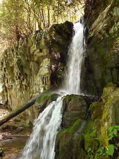
After we were on Baskins Creek Trail, we took ~0.5 mi. sojourn to Baskins Creek Falls; since this is not on the required trails for membership in The 900 Miler Association, I think that this was a first for all of us. Seeing the falls was truly worth the extra time spent (~0.3-0.5 mi. trip to it).


Somewhat to our surprise snow can still be seen on Mt. LeConte. This could be that remaining from the more than three foot of snow that fell earlier this year, or it could have possibly snowed last evening since temperatures at this elevation woul have been below freezing.


The next picture that I took of my 3-cohorts was a bit better than the one that I had taken near the start of our hike; from left to right they are Amie, Ellie, & Doug.


After we completed our hike (~12 mi.), Ellie shot this picture of Doug and me in Amy's van, enjoying our trip back to the Food Lion and our vehicles in Maryville; Doug and I were a little disappointed that Amy had not provided us with champagne. Nevertheless, it was a very nice hike with good company, and perhaps the most relaxing post-hike return trip that I have ever experienced.


P.S. Readers of this blog might be interested in viewing two blogs of fellow hiker Liz Etnier, namely (1) Wildflower Blog at www.myopera.com/smokieshiker and (2) info on an excellent GSMNP hiking manual at www.smokymountainshiking.com

Wednesday, April 14, 2010

Post 900 Hike #103: Anthony Creek--1.6, Russell Field--3.5, AT--2.9 +~1.5

Our hike's terminus was Rocky Top; we then returned (AT ~4.4, Bote Mtn--1.7, Anthony Creek 1.9 & 1.6. (Unfortunately I forgot my camera.)

Just prior to our departure at Food Lion, Ellie Doughty asked each of us to carry two tangerines that she would purchase to give to "through Hikers" on the AT; Ellie (who completed the AT as a Section Hiker) knew how well received these tangerines would be.

Cecil Rowe and I departed Food Lion ~08:10. At the Townsend Y we went with Ellie, Rita Haynes, and BZ Lane to Cades Cove. We started on Anthony Creek ~09:00 and were on Russell Field Trail ~09:30. We arrived at Russell Field shelter on the AT at ~11:30; here we gave out 6 tangerines to through hikers; each immediately devoured one (bear in mind that these hikers had been on the trail for more than one week--this was their first fresh food in some time). We ate our lunch there and were on the AT at 12:00. At ~12:50 we had finished our first section of the AT and we decided to hike the ~1 mi. section to Rocky Top (~500 ft gain in this mile). I went ahead here but only got my HR up to 145 bpm; I passed the brother sister couple from Mass. with whom we spoke at the shelter. By the time that all five of my group arrived, 6-through hikers were also there; with Ellie's permission I gave my last tangerine to the brother-sister couple. As we talked with these two plus four other through-AT hikers, I believe it was BZ who pointed out Shuckstack Tower (visibility was great); these through hikers visited it after ~3 mi. in the GSMNP; it really gave a great perspective of their last ~13 mi. of their ~2200 mile trip. While at Rocky Top I received a few insect bites and had a bit of swelling; fortunately I had some Benedryl with me.

As per usual I took it easy on the downward trek from Rocky Top as well as our succeeding trails to our return to Ellie's car. When we arrived there I iced my knee; we arrived back at the Y and my SUV ~17:30.

It was a good hike of 16+ miles; moreover, I added 2.9 mi of the AT (+ ~1.5 mi. to Rocky Top) plus 1.7 mi. of Bote Mtn to my Geezer Map (i.e., trails/mileage that I have completedd subsequent to reaching age 75. My pedometer registered slightly over 16 mi. for today's hike. It was a lovely day and a very good hike; again I am sorry that I did not have my camera.

I arrived back in Mayville ~18:00 and stopped at Taco Bell and picked up a sinful supper.

Wednesday, April 07, 2010

A Cumberland Trail Hike

My first hiking priority is to either help individual attain requirements for admittance to The 900 Miler Association of the GSMNP or to enable me to complete my Geezer Map (i.e., complete 900 Miler Association requirements after reaching age 75). Because no one needed my help today I decided to do a hike outside of the GSMNP that was organized by Gary Niebart and Mike Miller (the latter two were most instrumental in "firing my interest" in completing the requirements for The 900-Miler Association). Mike and Gary have proposed a series of Cumberland Trail hikes; it is my understanding that the completed sections are in State Parks.

I arrived at the Flying J service station on I-40 West ~0800. Somewhat to my surprise ~30 hikers were going to do this "Out of the GSMNP" hike near Dayton TN; I expected far less since this hike required a rather long drive. In part because I drove ~150 miles last week so that two hikers could complete the AT from Davenport Gap to Mt. Cammerer, I willingly accepted a ride with Jim and Nancy Carmin for what appeared to be a similar long drive.

We began our hike ~0930; in addition to Nancy and Jim, those in our "group" included Marita Vornehm, Debra Barton and Judy Collins. Judy was every bit as responsible as Mike and Gary in helping me complete my requirements for membership in The 900-Miler Association (Judy completed her requirements for the latter shortly after Gary and Mike and she invited me to go with her on hikes that required exceptional amounts of logistics). Although we had stayed in touch, I had not hiked with her since she completed her last hike for The 900-Miler Association in 2006. Judy has an "articular cartilage deficiency" in one knee for which the only final solution is a TKR.

Because no one in our group had a map, it was a rather unique hike. The first picture (you'll need to double click it to really see) presents Nancy leading, followed by Debra, Marita, Judy and then Jim.


We worked our way to a summit and intended to cross a stream; however, after I went a few feet and found that moss on solid rock was very slippery and that water level would exceed boot height for a few feet of the crossing, we retreated and had lunch. The next picture is one of several unique bridges that we crossed; if you enlarge the picture you'll see one of our group just getting off the bridge and two further ahead on one of many unique rock formations that we traversed and/or saw.


Shortly after this we met many others of our group who had taken a different trail initially; we decided to go where they had gone and came across the falls seen in the third picture.


We then worked our way back to the trail that we had initially taken; we eventually again passed the entrance to an old coal mine and/or a furnace used to make coke.


The hike that my group did today was perhaps only ~10 miles. The rock formations seen were very unique as were some of the stone walls, vistas, and a trestle for a bridge that did not appear to be going anywhere; much of this probably related to tree cutting (much done by Bowater) and its coal mine era. Although I am glad that I went on this hike, I am not sure how many of the Cumberland Trail hikes that I will make. I like hikes where the distance driven is more proportional to the length of the hike.

EPILOGUE: I am no longer allowing comments on my blog for the far majority (as of lately) have been anonymous trash. If you sincerely wish to respond to my blog I would love to hear from you at wliemohn@gmail.com.