This blog covers my Smoky Mountain hikes; it also includes a link to pictures from one of my cross country ski ventures.

Monday, July 31, 2006

Newton Bald—4.7, Mingus Creek—2.8 PD, 2.9 N, Oconaluftee River Trail 1.5 N


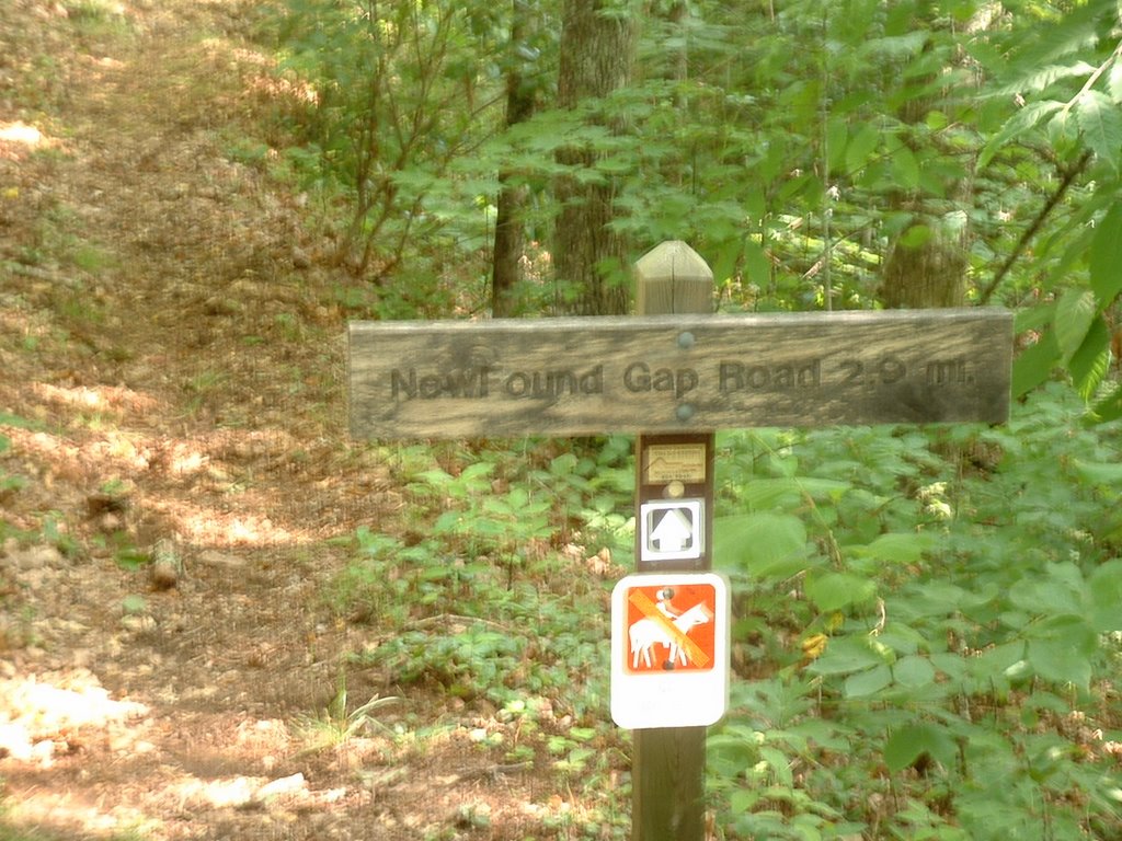
Had originally planned to camp at Smokemont and also get Kanati Fork and Kephart Prong done; however, wife talked me out of going Sunday (Jim Harb also needs latter two trails). Walked across US 441 and the trailhead for Newton Bald was ~250 yds toward NG. Started the 3000 ft climb on Newton Bald’s 4.7 mi. at 7:47 and arrived at its terminus at Mingus Creek at 9:37. Although I had originally planned to go in and out, I decided that it would be more expeditious to cover the 2.8 mi. of Mingus Creek previously done and then get back to US 441 on the 2.9 mi. section of Mingus Creek that was new rather than do an in and out on it. At 10:44 I finished the first section of Mingus Creek; although I saw a switchback the signage did not identify it and my choices at first seemed to be to go where I did not want to go or to return where I had just been. I then looked further down the switchback and sure enough there was a sign indicating that it would take me to US 441 (see pic). The latter trail had a section that truly made me appreciate that I was going down rather than up; the last section was just road and I arrived at Mingus Creek at 11:42.

Although there were a few cars at Mingus Mill, I ventured out on US 441 and wondered if I should walk to Oconaluftee Visitor Center (~1 mi.) or walk back to my car at Smokemont (3+ mi.). I chose latter hoping that someone might feel sorry for me and give me a ride. I was quite sweaty (not sure if my Bounce would cover odor); thus I thought that the only appropriate vehicle for me to ride in would be a pick-up (in its bed—I would have even ridden on a motorcycle). So I just buckled down and used my poles like I was going up a mountain (in this case US 441). In retrospect the countless cars that passed me probably just assumed that I was trying to set a record in getting to Newfound Gap; I finally got to my car at 12:35. Somewhat to my surprise on the way up where the road is close to the river I saw a woman laying on a rock in midstream; her pose (topless) was such that had I looked closer I might have seen someone painting her. (I did not take a picture for it would have upset my stride.)

After snacking in the car while icing my knee, I drove down to the Visitor Center to do the 1.5 mi. Oconaluftee River Trail; this took me 30 min. The neatest thing about it was reading the Indian lore written in English (and apparently in Cherokee). After taking a picture of the trailhead from Cherokee (see pic), I then retraced my steps and went back to my car. My mileage for the day, including the trek on US 441, was 16 mi.

Wednesday, July 26, 2006

Palmer Creek--4.9, Balsam Mtn--2.3, Mt. Sterling Ridge--7.4, Mt. Sterling--1.8, Mt Sterling Gap--0.5


This is a hike that Lowell Reid did the groundwork and I assisted. Somewhat to our surprise we ended up with 13 hikers; we had originally planned for 10. Met at Food Lion at 7:00 and then picked up Bob B. and BZ at SVC. (In retrospect we realized that taking I-40 most of the way would be better and Bob & BZ could have met us at Exit 451.) Three cars then drove ~70 mi. to Mt. Sterling Gap. At this juncture I locked mine and while 8 commenced the hike here, BZ, John, Pam, Judy and I went in their two cars ~8 mi. down the road where the five of us would commence our hike and the others would finish.

Although we had more elevation gain on our hike, much of it was easy. I went ahead after our late lunch on Mt Sterling Ridge trail so that I could ice my knee; the last 1.4 mi of latter trail got a little tiring for it was a bit up. (On this stretch I took the picture showing Pisgah National Forest.) Although Mt Sterling trail was mostly down, ~75% was very rocky and not too much fun; the final section of it and the 0.5 mi section of Mt Sterling Gap trail were easy. (All trail miles today were new for me--no repeats.)

When I arrived at my car (7 hrs 15 min after starting) Anne, Betty S. and BJ were getting into their two vehicles; they had taken a totally different hike than our group of 13. At this juncture a Park Ranger (police-type) drove up and we talked for a bit; he actually held my back door so it would not close as I iced my knee. He told me that where we started our hike was where elk were very prevalent just before sunset. He waited until my 4 co-hikers returned to my car; in our discussion it became apparent that he was concerned about a group that was back packing, and who had possibly done something inappropriate.

Wednesday, July 19, 2006

Lead Cove—1.8 & Bote Mtn—2.9 (repeats), Eagle Creek—8.7 (new)


I was responsible for organizing this hike; this included contracting with Fontana Marina, ensuring that all three groups (i.e., those doing Eagle Creek—N=12, those dropping off the Lead Cove hikers at trailhead and/or driving to Lake Fontana to hike Lakeshore trail and then transport hikers home—N=3 vehicles/4 hikers, & those doing Bone Valley plus—N=3). Everything worked fine because people like Martha Sundquist, Bob Hutchins, & Bill Woodrick got us to the trail head and then took the long drive to Fontana, and although they were able to do a short hike, they enabled the rest of us to make the longer trek. Pam Reddoch, Judy Collins, and John Kennerly scheduled their hike so that it would interface with ours and facilitate getting a good boat pick-up price (we had 19 hikers but one of the cancellers paid for the boat too so we were able to get the Marina’s lowest price). Teamwork was truly in evidence.

A litany of events resulted in a late start of ~45 min. at the Lead Cove trail head. Debbie Way, Nancy Cain, Bob Bolinger, Dale Teague, Betty Stamper, BZ Lane, Cecil Rowe, BZ Lane, Nancy Olsen, Tom Wainner, and I were the hikers. Lead Cove, as well as Bote Mtn that followed it, had a lot of climb and was not too popular. Eagle Creek had two facets. The first was steep (going down) with many rocks on the trail; the second was a modest decline with many stream crossings (15 identified as being difficult); I had my water shoes on for at least the last 10. My shoes gave me pretty good traction on the submerged rocks; my two poles also made it easier. However, a number of our group took one or more spills.

Believe that our 1st contingent arrived at Campsite #90 at least by 4:15; I was concerned because neither the Lakeshore or Bone Valley hikers were there. However, I learned when the first pontoon boat arrived that they had already been picked up. I collected $13 from each hiker in my boat and Bill Woodrick did the same in the other; we arrived at the marina ~5:00. Unfortunately today I forgot my camera; the shots shown are courtesy of Charles Wilder (he really has the knack of capturing the beauty).

Friday, July 14, 2006

Cooper Road (5.5), Hatcher Mtn (2.6), Li'l Bot/Hannah Mtn (1.9), Rabbit Creek (5.1), Wet Bottoms (1.0)


Started on Cooper Rd. at 8:55; finished 5.5 mi. at 10:50 (pedometer registered only 5.2). Finished Hatcher Mtn. at 11:50; thus pace was ~2.8 mph. These trails were relatively easy (not sure if pulse exceeded 120 bpm); I obviously stride out more when alone and/or am on trails of this ilk. (Another factor for relatively good pace is that I walk/jog my pup a minimum of 1 mi./day, jog at UT 2X/wk, lift weights 2-3 times/wk, and hiking 1-2 times/week; because of this regimen I believe that this almost 72 year old is in better shape now than I have been for years.) However, my good pace was about to be history.

When I had done Abrams Falls with Betty Jones months ago, I noted a challenging stream crossing. After lunch I donned my water shoes and started across I realized that my zip-locked keys and wallet might be vulnerable; after putting them in my pack I then realized that my camera was also vulnerable (may have been too late). I finally made it across; however, when I reached the rocks on the other side I fell down (not in the water but on rocks). This water crossing was the toughest that I have ever done.

Did Hannah Mtn until I reached Rabbit Creek. Rabbit Creek was mentally and/or physically tiring. At the end of Rabbit Creek, after again putting on my water shoes and wading across, I finally saw people. I then went for Wet Bottoms; unfortunately I made a 1.0 mile hike ~a 2 mi. hike. Eventually arrived at my car on the Cades Cove Loop and began icing my knee.

Wednesday, July 12, 2006

Huskey Gap Trail--2.0, Sugarlands Mtn--4.1, Sugarlands Mtn--4.8 new


Today's hike attracted a number of hikers; however, as might be expected most wanted to take the trail down rather than up. Because a key swap was the only way that this hike could work from a logistics perspective, we needed 4 hikers to take the upward trek. John Kennerly, Cecil Rowe, Charles Wilder, and I took this onerus task. We met the "down" hikers about 12:00; although their first contingent ate there we chose to go on to Rough Creek and ate with a second downward contingent. During these encounters each of the four of us picked up the key for the vehicle that we were to return to the Southern most point of our hike after we reached the point from which the downward hikers started; thus at the end of the day each of us could get back to our homes. Although the weather cooperated, the hike was not the easiest in that ours was an upward trek ending beyond Newfound Gap.
The first picture is one that John took of Cecil and me on our way up; the second picture is one that I took of Charles (our 4th hiker). Charles is the webmaster for the GSMNP and takes some fantastic pictures, primarily of flora; this is an example of what happens when he sees a neat flower. (Incidently, National Geographic will have a feature in their next issue of the GSMNP; this feature will cite Charles's web site of his pictures.)

Wednesday, July 05, 2006

Newfound Gapt to Clingmans Dome (AT 7.9 + .5 mi)


We left Food Lion at 8:00. Mike Miller drove; Anne, David, and I were passengers. At SVC we met up with Bill Broome, BZ, and Bob. A few others were going to do a slight modification of our hike led by Tom; David went with them. To facilitate transportation, BZ offered to hike from NG to CD if someone joined him; Bob and I did. Bill, Anne, and Mike dropped us off at NG and drove BZ’s truck to CD and started from there. Three other hikers from our group also started at CD, but got a later start.

We got on the AT at NG ~9:40; we met Bill, Anne and Mike fairly close to noon. The spot was not ideal for lunch so we kept on going and stopped later. Going up as we did is ~1600 feet differential; however, the total climb was more for we also had a few descents. We arrived at the base of the observation tower at CD ~1:10. After I took a pic of BZ & Bob, a friendly tourist took a picture of the three of us. Because it was quite a bit cooler there we put on our rain jackets there prior to our 0.5 mi. walk to the CD parking lot and BZ’s car. We picked up Bill, Anne, and Mike at NG; they had eaten lunch at Indian Gap and then it really started to rain, so they walked back to NG via the road.